The Open Space Plan
While the shape of this city is a curse for transportation planners, it is a blessing for anyone who even just occasionally wants to get outside, because the city’s edges are close by and full of opportunity.
We don’t all take advantage of this though. There’s lots of good and bad reasons why people don’t, ranging from a lack of information, or ability, or inclination, or time. I can’t believe it took me nearly 20 years of living here before I discovered the Skyline Track. I just didn’t realise that I could open that gate and walk up that road I’d noticed on the hill across from our house. Now, one of my favourite weekend activities is an hour or so of walking or riding through open farmland followed by the simple joy of standing on the biggest hill around and saying “I can see my house from here”.
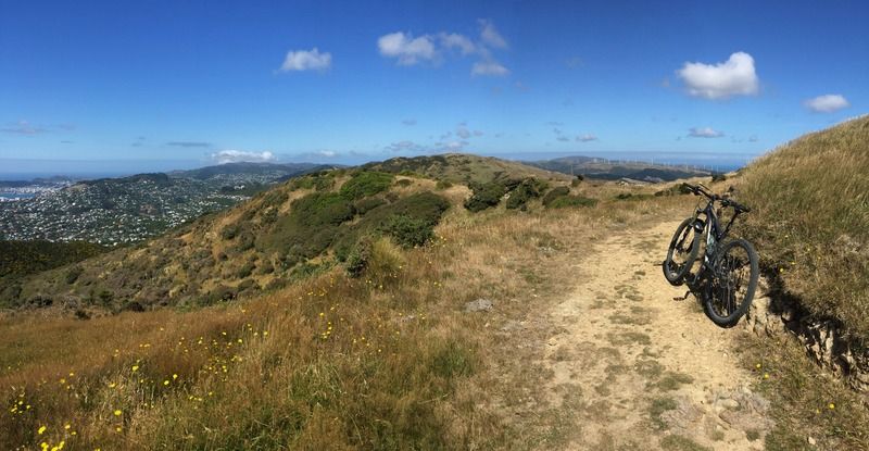
But as well as hills to climb, there are trails to run, coasts to scramble, forests to breathe, valleys to stroll, and tracks to cycle (this latter being my favoured activity).
Which leads me to the Wellington City Council’s Open Space Plan, on which the Council is collecting submissions right now.
The Council say:
Walkers, runners and cyclists enjoy over 340 kilometres of walkways and tracks in Wellington City. To ensure these are well-managed and planned for the future we are doing a minor review of the Open Space Access Plan 2008. This plan guides the use and management of tracks and walkways in and between the city’s open space network.
The review proposes opportunities for electric bike (e‑bike) use within the open spaces network, and an updated implementation plan for track planning and development.
The most alarming aspect of this review for me was the mention of e‑bikes. However having now read the document it seems that e‑bikes – these being low-powered pedal-assisted electric bikes of the sort you see increasing numbers of on the streets and soon, mountain bike variants – are unlikely to be allowed on dedicated uphill mountain bike tracks such as those at the Makara Peak Mountain Bike Park.
As someone who has occasionally volunteered over there I can imagine the wear and tear on tracks would be increased with e‑bikes (power skids are generally frowned upon by track builders and maintainers). To balance that though, the tracks will be more accessible to more people if e‑bikes are allowed, and that must surely count as a good thing. Most MTB track networks have alternate uphill routes – old forestry or farm roads – and these will enable e‑bike users to get to the top, ready for a downhill cruise, without affecting the uphill singletrack routes.
The most exciting parts of the review for me refer to a couple of new tracks, which when complete should open up some amazing countryside and lead to some truly epic adventures.
The first is a proposed coastal track from the end of the Red Rocks track right around the south and western coast all the way to Makara Beach. It would be a bit far for me to walk or run (though plenty would) so I am hoping it would also be open to cyclists. This would be a pretty fantastic full day activity (pick your day carefully!).
The second is a hilltop route, apparently following an old Māori trail, from the hills above Crofton Downs across the ridges to Makara. Again, I have hopes that this would be open to cyclists as well, as it would provide some great off-road connections to the Ōhariu Valley, Makara Beach and West Wind.
There are some other proposals as well, which will add to the existing network and make it more easy for people to access smaller parts of the longer tracks so that they can split the activity over several sessions easily.
But the council also want to know:
- whether paper roads should be included into the open space network
Yes! Roads, even paper roads are public land after all, and the big ones here are in the farmland west and south of Karori. But this will need a pragmatic approach from us, the potential track users. Like as happens today in other areas on the edge of the city (e.g. Belmont Regional Park), there will be times the owners of the surrounding farmland will need to close the tracks to public access.
- whether cyclists should be encouraged to use a bell
I think the issue here is likely cyclists not announcing themselves appropriately to walkers when on shared trails – and while a bell is a useful way to do this it’s not the only way. Bells can be pretty abrupt and I have severely startled some walkers from time to time using mine. I prefer to call out these days; making sure to slow right down when passing.
The council’s proposal to designate some tracks (just a few!) as mountain bike priority should also help set expectations for both cyclists and walkers here.
- if accessibility within the open spaces is adequately addressed.
There’s definitely more to do here, from better signage and more maps and mapboards, to creating more sealed and graded tracks allowing people in wheelchairs and those of limited mobility – or even just limited time – to enjoy the amazing spaces we have. Some more integration with transport networks would be great as well, even if (for example) that’s just making sure potential track users know how to get to and from each end of that section of the Northern Walkway they’ve decided to tackle today.
But those are just my opinions, and there’s certainly a lot more to think about in the council’s documentation than I’ve written about here. You might have your own opinions… and if so, you should make a submission!
And if you haven’t had a good look at Wellington’s track network then get a map or download the app and grab the next fine calm weekend day. No-one should have to wait 20 years before they discover what’s out there on their doorstep.
Submissions close 5pm 13 July, here.