Notional Significance: Gorge
[See all Notional Significance posts]
The stretch of Hutt Rd from Kaiwarawhara to Ngauranga is a long, dry slog through an artificial valley. The western side is almost natural, covered by tenacious regeneration, but often cut, buttressed and battered to keep the slope from failing, occasionally sliced by gullies and roads that scrabble up to to the moneyed cliffs above. The eastern side is poorer in every sense. Between the road and the low bank of motorway that forms the other wall of the valley there’s a ribbon of half-land, initially littered with faltering industry and big-box DIY (Placemakers in a placeless space), then a strip of scrubby green which exists only to mitigate and separate. Its only role is to not be anything else.
At the cusp between the two lies an abandoned petrol station. On dirty glass the clean type reads “VENDING ROOM CLOSED”, then apologises corporately before informing you that “Cold drinks are still available from the vending machine”. But that too is dead — electricity deactivated, coin slot gathering rust — and the toilets (“Exeloo facilities are designed for your comfort and safety”) are equally defunct. It’s an instant ruin of the Oil Age, as blind, empty and obsolete as the thinking that continues to pour billions into motorway construction. Unserviced and inconvenienced, I drag myself onward.
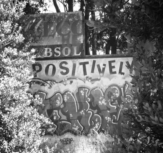
The rail lines begin to diverge, the Hutt-bound tracks now hugging the pavement while the Main Trunk loops away and climbs a gentle bank, winding up for its leap into the hillside. I check the Hutt line both ways, check again for anyone watching, and hop across the white railing and the narrow tracks. I enter the non-land, the “verge” in many senses, a parkland glimpsed from car or carriage but never intended for human habitation. The combination of soft lush grass and modest copses should evoke the eternal savanna, the evolutionary Eden of Duttonesque reverie, but instead it’s an uncanny valley of landscaping wrongness. Captured rivulets trickle blindly among weeds; cars growl and thunder just out of sight; rails and warning signs admonish interlopers; the only spoor is rabbit droppings and graffiti on rotting billboards.
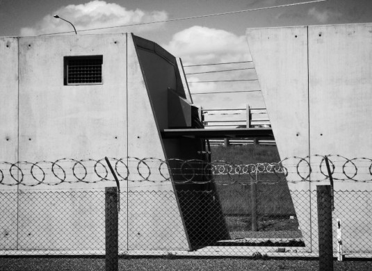
At the point where the North Island Main Trunk Line clambers over the road and into its first long tunnel, I scramble back over the lines and onto the footpath. The railway bridge is old iron, girders and rivets, but the network is dragging itself self-consciously into the 21st Century. Brand-new railway substations with aesthetic pretensions crouch beside the lines, tilt-slabs tilted in another dimension to evoke speed and progress, Futurist bunkers guarded by razorwire loops. Across the road there’s a small plaque attached to a pioneers’ horse trough, a filling station from the days before the Hutt Rd knew iron horses or horseless carriages. It languishes amid concrete and gravel, the remorseless creep of Tradescantia.
Finally I reach the base of the Gorge, and a clash of modernities. A tangle of flyovers do their Ballardian best to convey mid-century infrastructural virility; a geodesic half-dome on the hillside is redolent of techno-hippie escapism; but the warehouses of Jarden Mile and the nameless asphalt islands are exemplars of early 21st-Century Cheapism. Long-run, tilt-slab, bottom-line.
This clot of divided highways, side-ramps and non-roads is tough to navigate, but the bottom of the Gorge was always thus. The first European settlers had to pay Māori to ferry them across the river mouth in canoes, or even piggyback them one by one to avoid wet feet. After the first bridge arrived, half of Te Wharepōuri’s waka stood as a memorial beside the stream, before it succumbed to age and weather and crumbled onto the road, into sheds and forgetfulness. The Gorge was still untamed when the first highway came, the carriageway gouged away by floods in 1941, but the road bit back, eating into the bluff in 1963 when the interchange was born. The motorway consumed Fort Kelburn, which once guarded the harbour from the Russian threat, its only memory a stumpy road still called Fort St. Above the junction, the hills still loom: stark, watchful, unforgiving.
The stream itself is now humiliated, corseted between concrete walls or bound in stormwater dungeons, but now and again it reveals its old identity, tumbling in impatient rapids over boulder dams or coiling in deep, slow atavistic pools beside reefs of bare rock. Beyond the police dog training grounds, the river has to jump through its own hoops, an obstacle course of culverts and weirs, as it weaves back and forth beneath the motorway. Actually, “motorway” is not quite correct: though I’m back up close to SH1 for the first time since Thorndon’s terra firma, this stretch of Centennial Highway cannot strictly be called a motorway, not with a foot and cycle path beside it. Nevertheless, with a half metre of gravelly concrete to negotiate and only a kerb to separate me from six lanes of grunting, grinding traffic, the distinction seems moot.
This side of the road is clean, unlike the clutter that trickles down Glover St opposite: anonymous lock-ups; whiteware warehouses; big-box churches (muscular Christianity pumped up to industrial strength). Pylons stand aloof, holding power aloft. The walls of the gorge press inwards as the railway springs overhead, grabbing a fleeting gasp of light and air between the musty tunnels of the main line. Road, rail and stream entwine like braids, weaving their own modes of significance through the fractured landscape.
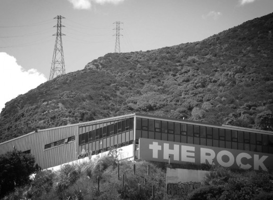
On my left is the valley where Alfred Tyer, king of the meat byproducts, once practised the ancient arts of tanning and fellmongery. His noxious, fleshly alchemy transmuted corruptible skin into enduringly protective leather, but the dominant industries now provide physical protection, transportation and elimination of the otherwise intangible products of the information age. Heavy walls bear the logos of Data Security Services and Document Destruction Service; windowless white vans carry the stout shield of ACM Currency Management. High fences, high voltage.
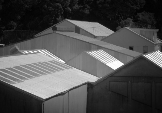
I detour up Tyers Rd, investigating the anonymous sheds that sit on an artificial plateau. They huddle at the base of the upper cliffs, ziggurat forms roughly carved from frangible bedrock. From the upper road, the big sheds on the old tannery site below almost achieve an abstract beauty: warehouse rooftops coaxed into a shimmering composition of angular forms. They’re part of an industrial park sometimes called “Transport Village”, though of course it’s all transport and no village.
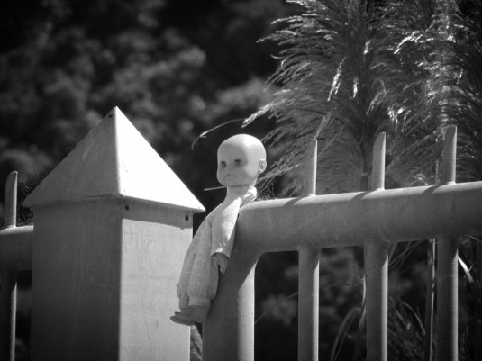
Motionless. Through dead still air the sounds of the highway come drifting up, mingling with cicada song in the fierce flat heat of summer. The built environment is mostly predictable, the edgelands lingua franca of asphalt and corrugated metall, but amid all this there are touches of exurban surrealism. The substation is done up like a PoMo swimming pool, its elemental power of transformation (and transformation of power) domesticated in baby blue tiles and stucco, camouflaged with faux-Deco and cod-Classical flourishes. And then I’m struck by the unsettling innocence of a baby doll, impaled in either macabre humour or unhinged malice upon the railings of an unknowable depot.
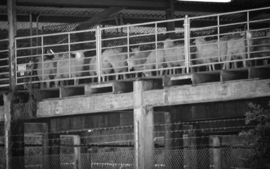
Back to the highway, and up again. The northeast slopes are raw and craggy, true gorge, where hunters still track and kill wild goats, but to the west the valley opens up into a broader basin, where docile animals and the earth itself are torn apart and processed for consumption. Shrill yellow hoppers mark the retail arm of the quarry that is slowly chewing its way north, crushing the landscape into bite-sized chunks of gravel. Further down the road, oblivious sheep spend their last animate hours penned beneath translucent roofs, stacked above barbed wire and an intestinal tangle of shining pipes. Warning signs brand me an intruder, but the blind trucks keep trundling by, paying no notice, so I wander further in, south of the abattoir.
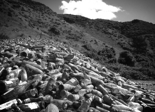
The landscape veers between industrial, quasi-rural and unearthly. A reticent stream trickles somewhere below, all but hidden in a wooded gully. A stock track meanders through tussock and gorse, and a simple weatherboard house stands sentinel on the hillside, alone amid the broom and fennel, oblivious to the looming wave of suburban sprawl on the crest of Mt Misery above. There’s something wrong with the gravel on the road: it glints and twinkles, crunches ominously underfoot. It’s more glass than stone, leading to a miniature mountain range of bottles and jars, piled into peaks and ridges that parody the hills beyond. The greens, golds and browns of the landscape are reflected in recycling — dusty drifts of Bernadino, Raguletto sauce, Corona, a mediocre Scotch. The road squeaks and shatters, tinkles like frost beneath my boots as I leave the crystal world and head back for the last leg of the gorge.
Trucks wheeze and grumble against the steepness of the grade, and I know how they feel. The road now cuts a deep V through ragged, serrated slopes, seven lanes of traffic choking out any last semblance of the gorge as natural landform. But after a few minutes’ slog the sky opens up and the road begins to flatten. An off-ramp peels away, before a fake-doored storage depot (perched on the ridge like a red-and-white caterpillar) and the diagonal slice of an overpass signal the promise of New Lands beyond. Pedestrians are herded away onto a segregated path, but before it slides into an underpass there’s a glimpse of something surprising: another deep cool pool among the regenerating bush, with the distant sound of falling water as a faint reminder of the power that originally carved this valley.
Even at walking speed, I can sense the slackening gradient, the impending ballistic pause at the apex of a parabola. Before the highway flattens, it passes beneath the Newlands overbridge, which is one for aficionados of the genre: bold stanchions like an inverted trident plunged into the earth, sharp-edged and steely, battleship grey. But then the road seems to get a second wind, coiling in preparation for another steady rise as it once again becomes honest-to-god Motorway — meaning that the footpath has to part ways from the highway. At last, my feet feel the fall of land as they follow the off-ramp down into the wide flat bowl of Johnsonville.

Beautiful writing there. The glass bottles took me by surprise.
It may be worth pointing out that Centennial Highway (that is, the gorge) is definitely not a motorway in the legal sense; it’s perfectly legal to cycle up it. If you’re driving along SH1 you briefly drop off the motorway while you go up the hill; the motorway resumes post J’ville.
Try walking down the other side of the gorge. The river is much more evident, and is quite pretty. But that little pool up by the pedestrian underpass to J’ville is one of the region’s little known treasures, I’ll admit.
Sir, I object to your description of the Caltex Fuel Stop as an “abandoned petrol station”. Just because it doesn’t have staff, pies, and two-for-one deals on Moros, doesn’t mean it’s not open for business. Trucks regularly stop there to fill up and pay with their Caltex fuel cards. The vending machine room and loos may have been closed, but the pumps are still very much open for business.
Thank you for the correction. It looked nearly dead to me, and I was concentrating only on my own bodily functions.
The Map of Notional Significance has been updated. This is one of the longest sections, and one of the fiddliest. With only certain landmarks and a general direction to go on, I rather enjoy guessing exactly what route Alf took.
Also – I had no idea this part of the motorway had pedestrian access. It doesn’t seem like a particularly friendly walk, but I like a challenge.
In my experience, this is one of the most-used and least known areas of greater Wellington. Virtually no-one’s seen it on foot. For example, hands up everyone who knew about the Ngauranga railway station? Unless you use it, it’s virtually invisible, tucked away in behind the overpass.
I can confirm that the Caltex petrol station is alive and kicking – cycling home of an evening, you need to keep careful eye for cars pulling in/out of it.
I had a play with FourSquare the other day, and someone is registered as the Mayor of Ngauranga Gorge. I suppose you have to start somewhere. Or do you?
https://foursquare.com/venue/480825
The pylon track (Wakefield Gully) is an interesting diversion on the north side too.
That’s Wakely Gully, not Wakefield. It’s a legal road on paper (though access is often cut off at the Newlands end by the gate). Good fun as a walking track, and is heavily used by commuters on mountain bikes going to/from the Northern suburbs.
Kiwi Point Quarry hosts an unprepossessing unit outside it’s office there
http://www.ipenz.org.nz/heritage/itemdetail.cfm?itemid=109
invented by a WW2 hero
http://www.navy.mil.nz/naval-reserve/naval-reserve-history/macdonald-reserve-hero.htm
and if you could still walk up the road at the back of that quarry it leads up to Fraser Ave – way back there used to be stockyards for animals associated with the meatworks which were just North of Raroa Station and may still be visible from the trainline.
The most barren stretch of Alf’s journey (so far) gets the best comments. I love this series so much!
And coming next – the most terrifying section of all – Johnsonville! The road narrows, even for roaring cars and trucks, just as it saunters overhead and then ducks beneath the sexy entry bridge to Wellington – just a little too tight for tall trucks to like… if Doctor Rune walks that bit, I’ll take my hat off to him!