
Where the Wild Wind Blows
We’re expecting some severe winds overnight and in the morning, and sensible people are battening down their metaphorical (and occasionally literal) hatches. I saw a comment on a friend’s Facebook page from someone overseas saying “but surely Wellington houses are built for the wind?”, and the answer is yes, but gusts of 160km/h are extreme enough to cause damage even to buildings designed for this brisk climate. I intended to link them to a map of building code wind zones…only to find that (as far as I can see) there is no readily-available overview map. The WCC’s WebMap will let you bring up a wind zone layer and click on the zones, but it doesn’t give you the big picture. So, I downloaded the wind zone data from Koordinates, and quickly knocked this together.
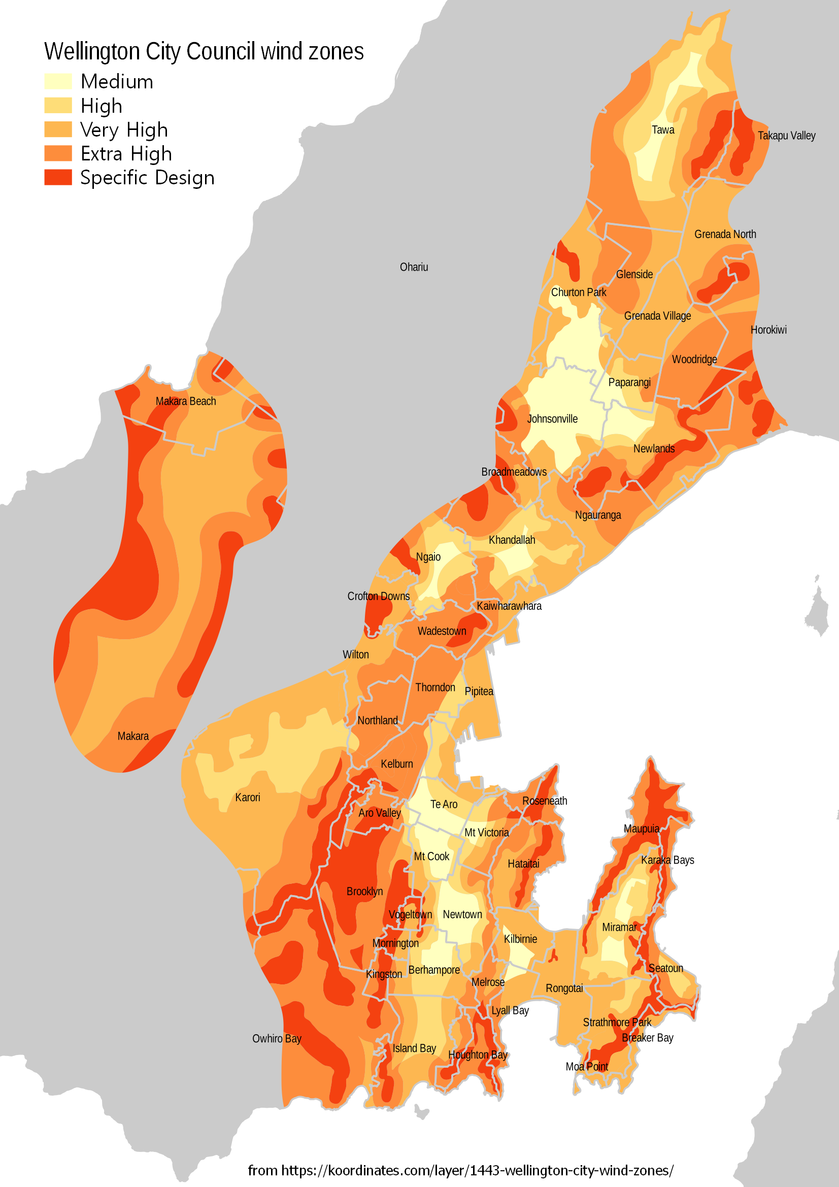
The zones are coloured from least windy in yellow through to windiest in red, with grey areas either outside the WCC area or not built-up enough to warrant modelling. The least windy areas, which are officially “Medium Wind” rather than Low (because Wellington, of course) are generally where one would expect: relatively flat and sheltered basins such as Johnsonville, Khandallah-Ngaio, southern Te Aro to Berhampore, Kilbirnie and central Miramar.
As you’d expect, anywhere hilly or on the waterfront quickly goes into the High, Very High and jolly-sounding Extreme categories. These zones help builders and engineers apply NZS 3604 to help work out the bracing demand, thus ensuring your house doesn’t get turned into kindling every time there’s a little gale. Hopefully. But Wellington doesn’t stop there. The fiercest red zones on the map are categorised as “Specific Design”, which is Building Code-speak for “you’d be crazy to try to live here, but if you must, get an engineer to work out how to stop you from flying away.” Unsurprisingly, these exciting areas follow the major ridgelines, though there are some intriguing local variations (for instance, Hataitai’s ridge seems worse than the main Tangi-te-Keo ridge of Mt Victoria).
I imagine that most of those who are blessed to live in the Special Design areas already know how to keep safe, and how their homes are affected differently in a northerly (like right now) vs a southerly (as in the 2013 storm). But this might help remind you to take extra care with closing windows, lashing down pets, and securing any garden furniture that hasn’t already relocated to the neighbour’s place.
[Photo by Per Bjørkum on Unsplash]